 by
by It starts like so many internet mysteries do. A set of coordinates. A blurry satellite image. And a claim that something ancient — or even sinister — has been uncovered.
This time, it’s a so-called “demon face” spotted deep in the mountains of southern Chile on Google Maps. And once you see it, it’s hard to unsee.
The Coordinates That Sparked a Viral Frenzy
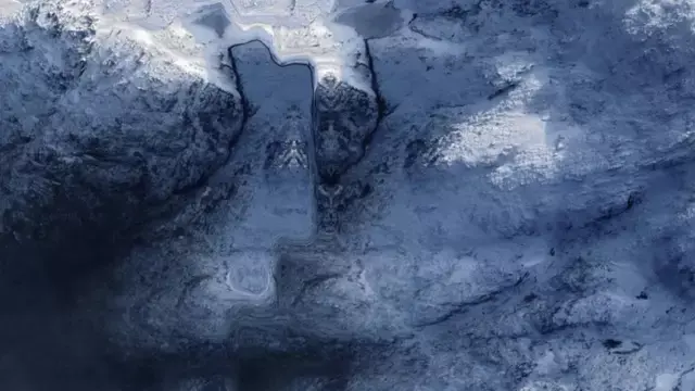
The image in question appears when users search the coordinates 55°32’40.0″S 69°15’58.0″W on Google Maps.
Zoom in, and the rocky terrain seems to form an eerie, symmetrical face. Dark shapes resemble hollow eyes. A jagged ridge looks like a grimacing mouth. For some viewers, the effect is instantly unsettling.
Social media quickly did what it does best. Screenshots spread. Theories followed. Some joked it was a “portal to hell.” Others wondered if something had been deliberately hidden in one of the most remote regions on Earth.
Where the ‘Face’ Actually Appears
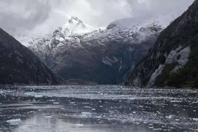
The location sits inside Parque Nacional Alberto de Agostini, a vast national park at the southern tip of Chile.
The park is one of the country’s largest protected areas and is known for towering mountains, massive glaciers, and fjords that are largely untouched by human development. It’s named after Italian mountaineer Alberto María De Agostini, who explored and photographed the region in the early 20th century.
It’s wild, remote, and sparsely mapped — which turns out to be an important detail.
The Science Behind the Illusion
As the image gained traction, science-focused accounts were quick to offer an explanation.
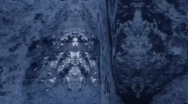
According to satellite imagery experts, what people are seeing is a mix of pareidolia and digital stitching artifacts. Pareidolia is the human tendency to see faces or familiar shapes in random patterns — like clouds that look like animals or faces in tree bark.
Satellite imagery adds another layer. In remote areas with frequent cloud cover, mapping systems sometimes mirror or repeat nearby visual data to fill in gaps. That process can unintentionally create symmetrical patterns that look strangely intentional.
Pan or zoom the image, and the “face” often shifts or breaks apart — a sign that it’s a visual glitch, not a physical structure.
Why It Still Feels So Creepy
Even with a logical explanation, many people admit the image is disturbing.
There’s something deeply human about reacting to faces, even when they’re not real. Our brains are wired to notice eyes and expressions, especially in unfamiliar environments.
That instinct is why similar Google Maps discoveries have gone viral before — from desert patterns to messages carved into the ground. Most turn out to be harmless. But the initial shock is real.
Social Media Reacts, Predictably
On X and Reddit, reactions ranged from amused to genuinely unsettled.
Some users insisted the symmetry looked “too perfect” to be accidental. Others joked about Antarctica conspiracies or hidden bases. A few admitted they felt uneasy just staring at it for too long.
What’s often overlooked is how little of Earth’s most remote regions are captured in high-resolution detail. When technology fills in the blanks, our imagination tends to rush ahead.
A Reminder About Digital Maps
Google Maps is an incredible tool, but it’s not a window into hidden truths. It’s a constantly updated digital model built from satellites, algorithms, and approximations.
In places like southern Chile — rugged, isolated, and cloud-covered — those approximations can look strange. Sometimes, strangely human.
And that’s usually where the story ends.
Featured Image Credit: Google Maps/Getty Stock